


 English (pdf)
 Article in xml format
 Article references

 Permalink
1. Introduction
The Guaraní Aquifer System (GAS) in Uruguay is developed in the so-called North Basin, covering around 43000 km2. It is made up of a succession of sedimentary formations with different permeability values1 connected hydraulically, with heterogeneous distribution within the basin, deposited from the Permian to the Cretaceous1. This sedimentary succession is covered, largely, by basaltic flow spills, which extend approximately 37000 km2, with a maximum power of 1200m2, constituting the confined area of the GAS.
Formations with no basaltic cover are found outcropping and constitute the outcropping area of the GAS. This area is located mainly in the departments of Rivera and Tacuarembó, occupying about 6000 km2 and arranged in a N-S belt, 160 km long and 40 km wide. This study refers only to the outcropping formations of Rivera and Tacuarembó, and takes the stratigraphic proposal of the Batoví Dorado Group3-4, consisting of three formations, which are: Cuchilla del Ombú Formation5, Tacuarembó Formation6 and Rivera Formation5, from base to ceiling. The Yaguarí7-9 and Buena Vista5)(9 are underlying these formations, which exhibit confined to semi-confined aquifer behavior in the study area. This sedimentary package represents the typical Guarani Aquifer System1 and is supported on Permian Formations that, from base to ceiling, are: Fraile Muerto Formation6, Mangrullo6)(8 and Paso Aguiar6. These aqueitar formations are presented with a heterogeneous distribution within the basin, according to existing distribution and isopaque maps10. The San Gregorio and Tres Islas Formations3-4 are found (from base to ceiling) below this marine shelf sedimentation, from upper Carboniferous age11 to lower Permian7)(12, respectively, forming a second aquifer system. It should be noted that despite the different porosities and permeabilities of the sedimentary formations that constitute the typical GAS, there are hydraulic connections among them, as well as with the Carboniferous-Permian aquifer system (2021 conversation with Montaño; unreferenced). The sedimentary formations that form the Basin do not occur simultaneously in all their extension, they are conditioned to the paleoenvironments of sedimentation and paleotectonics, affecting the hydraulic and chemical characteristics of groundwater, evidencing the great heterogeneity of the Guarani Aquifer System in the different countries1.
This study aims to know the petrographic characteristics and porosity of the sandstones that belong to the hydrogeological units of the outcropping Guarani Aquifer, which directly influence their permeability and the chemistry of groundwater. Sandstone porosity is directly related to the shape and size of the clasts, arrangement and diagenetic regime13. The use of sedimentary petrography tools for the evaluation of porosity and compositional characteristics is of great interest in hydrogeological studies. A specific objective is to evaluate, qualitatively and quantitatively, the porosity of the sedimentary rocks of the Cuchilla Ombú, Tacuarembó and Rivera formations.
Table 1: Stratigraphy of the Guarani Aquifer System in the outcropping area of the departments of Rivera and Tacuarembó, Uruguay. Modified from Collazo14
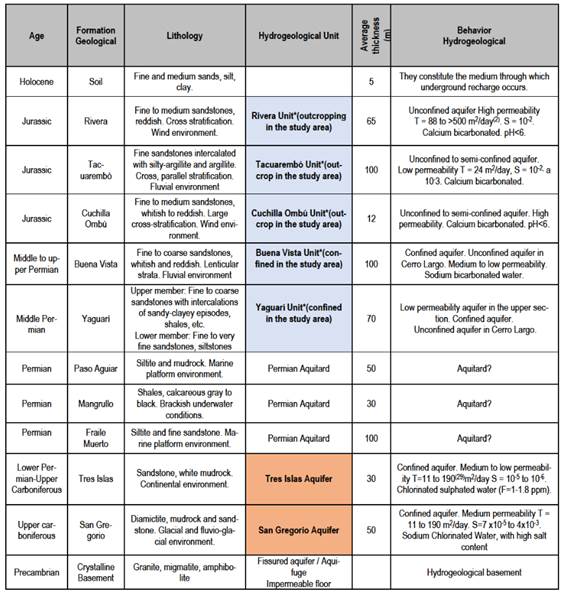
*Constituent units of the typical Guarani Aquifer System in the study area14.
Most of the data were collected within the framework of the doctoral thesis "Hydrogeological Research of the Guarani Aquifer in the outcropping area of the departments of Rivera and Tacuarembó, Uruguay"14, first studies on sandstone hydrogeology and sedimentary petrography of the outcropping GAS. They are re-analyzed and re-interpreted in this study, while providing new data.
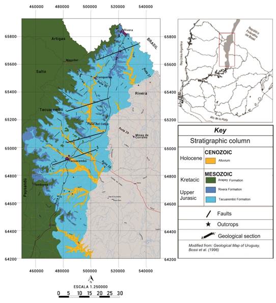
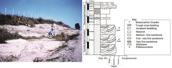
Figure 1: Geological Map of the outcropping area of the Guaraní Aquifer System in the departments of Rivera and Tacuarembó, Uruguay14
1.1 Geological Characteristics of the outcropping GAS
The outcropping formations from Rivera and Tacuarembó which are part of the typical GAS are described next, from base to ceiling.
Cuchilla del Ombú Formation: It was defined as an independent stratigraphic unit5. It is made up of medium to fine quartz sandstones, with little clay matrix, well-rounded grains and polished surface, and with very good selection. Stratification is tangential cross, with measured paleocurrent directions from N25E, N45W and dip 27° to 28.5°, the sets reach one and a half meters thick approximately14. The sandstones of this formation clearly show an aeolian origin and were considered as large barchan dunes3-4)(15. It develops discordantly over the Yaguarí6 - Buena Vista Formation and underlies the Tacuarembó Formation discordantly. The absence of fossil remains makes its dating difficult and a Lower Jurassic tentative age is assigned4. It is recognized on the surface and is restricted to the center-east of the area, leaning on the Yaguarí Formation. Typical outcrops can be seen on route 59 and in the locality of Cuchilla Ombú (Tacuarembó). Towards the W of the basin, its development and thickness are unknown. In Paso Manuel Díaz (Rivera) it is supported on a crystalline basement.
Tacuarembó Formation: Recognized and named as “Areniscas de Botucatú”15, designated as “Areniscas de Tacuarembó”16 and later ranked in formation6. The formation was divided into two members. The lower member comprises sediments deposited in underwater conditions, alternating very fine to medium quartz sandstones, whitish, pinkish and greenish, with cross stratification and horizontal lamination, and greenish to brown mudstones, with intraformational conglomerates. The upper member is represented by fine to medium reddish quartz sandstones of aeolian origin, with planar-tabular cross-stratification17-18. This division was reconsidered, designating the sandstones of aeolian origin in the lower member as the Tacuarembó Formation sensu stricto and the sandstones of aeolian origin of the upper member5) as the Rivera Formation.
The Tacuarembó Formation is then formed by very fine to medium quartz sandstones, with planar cross-stratification and with green, pink or grayish colors, which are intercalated with pinkish siltstones and shales, passing through violet to greenish, currently considered as the lower member. The upper member is considered as another independent stratigraphic unit, called the Rivera Formation5. The Tacuarembó Formation corresponds to deposits related to an underwater environment at the regional level17, with fluvial and/or lake episodes of periodic floods6 and anastomosed rivers19. An Upper Jurassic age is assigned20, based on the finding of several teeth and a dorsal fin spine from a freshwater shark. This formation is transitionally supported by the Cuchilla Ombú Formation. It is possible that these lithologies develop on the Permian age units, towards the south of the department of Tacuarembó21. Towards the top, in its outcropping area, it is covered discordantly to a lesser extent by the Rivera Formation, mainly to the north and west of the region. Regarding its power, thicknesses of 80 m18)(22, and 50 to 100m23 are proposed according to various authors, including the Cuchilla Ombú Formation at the base and the Rivera Formation at the top. On the other hand, based on drilling descriptions of the State Sewage and Water Works (OSE by its Spanish acronym), an average thickness value of 94 m14) can be estimated. This formation constitutes the subsoil of the city of Tacuarembó24, which is why it bears its name; the typical section can be seen in any profile near this city, on national routes 5 and 26. This unit outcrops along a belt with an approximate NS direction, from the city of Rivera to the south, considering the Arroyo Malo and the town Los Cuadrados as the southern limit14.
Rivera Formation: It is composed mostly by middle sandstones and some breccias or basal conglomerates, which show an aeolian environment with an extensive field of dunes that extends towards Brazil and Argentina, marking a period of significant desertification in the Paraná basin5. Regarding the age, the upper limit is certain and it is determined by the basalt spills grouped in the Arapey Formation6 corresponding to the Lower Cretaceous (130-133 Ma25). Contact with the Tacuarembó Formation is discordant. The Arapey Formation basalt spills constitute the ceiling of the Gondwanic sedimentation and the western limit of the study area (Figure 1). There is no certainty about the maximum thickness of the Rivera Formation, but data from deep drilling carried out by OSE in the surroundings of the city of Rivera have shown average thicknesses of 65 m14.
2. Material and methods
Samples were taken from the most representative outcrops and passed through different sieves with different openings (0.500, 0.250, 0.125, 0.063 and minus 0.063 mm) in the laboratories of the Institute of Geological Sciences of the Science College. Rotap was used for the passage of sediment through the sieves. In this way, the different subpopulations were separated and the weight percentage that corresponds to each one could be established. In order to carry out the petrographic study, 20 thin sections were analyzed (9 corresponding to the Rivera Formation, 10 to the Tacuarembó Formation and 1 to the Cuchilla Ombú Formation), after recognition and sampling in the field of the mentioned units (Chart 2). The thin sheets were made in the Sections Laboratory of the Institute of Geochronology and Isotopic Geology (CONICET-University of Buenos Aires). The percentages relative to the clastic components (QFL detrital modes) and of the autogenic minerals were made from the count of 300 to 500 points using the Gazzi-Dickinson method. The petrographic classification was carried out according to Dickinson26. The samples were vacuum impregnated with blue epoxy resin, in order to facilitate the determination of porosity. The value of the total porosity in the different sandstones was determined from optical methods based mainly on the counting of the empty spaces through the petrographic microscope, and later using the software Phase Expert of the Institute of Geological Sciences of the Science College. The effective porosity value was determined using the granulometric correlation method (Briggs and Shantz formula)27, where the effective porosity is the total porosity minus the specific retention (mr)m r = 0.03 (% sand) + 0.35 (% silt) + 1.65 (% clay).
The study was complemented by the analysis of textures and chemical composition, carried out with a scanning electron microscope, equipped with an X-ray microprobe (EDS energy dispersive X-ray spectrometry), in the Electron Microscopy Laboratory of the Science College.
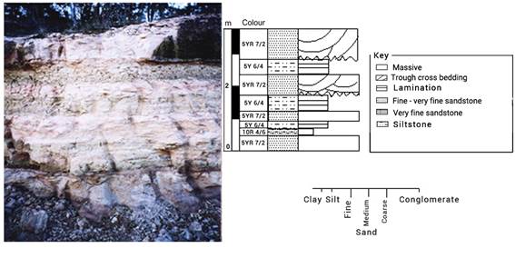
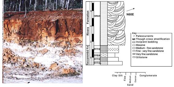
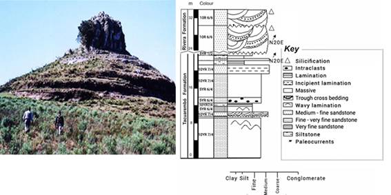
The sampling points for the preparation of the profiles and the thin sectioning were: (a) Route 5, km 480, Rivera Formation in contact with the Tacuarembó Formation (Figures 2, 3 and 6); (b) Route 59 representative outcrop of the Cuchilla Ombú Formation (Figure 4) and Tacuarembó Formation (Figure 5); (c) outcrop of silicified sandstones of the Rivera Formation in the town of Cerro Alegre; (d) Cerro Batoví (Figure 7) and several isolated outcrops in order to cover all the formations that make up the outcropping GAS. The sandstone colors were determined using the chromatic standards of the Rock Color Chart Committee28. The Corel Draw software was used to make the profiles.
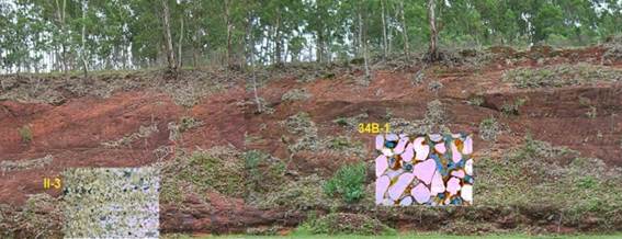
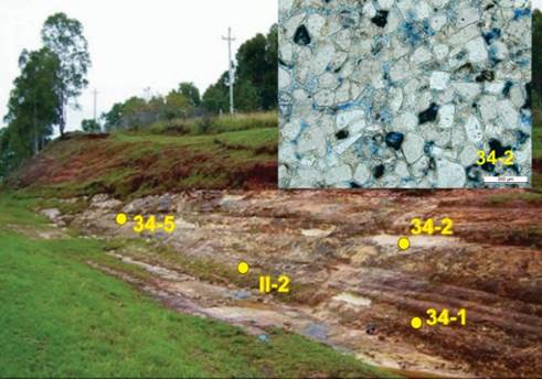
Figure 3: Sampling points for thin sectioning in the Tacuarembó Formation. Contact with Rivera Formation (see Figure 2)
3. Results and discussion
The following results were obtained from the petrographic study (Table 2):
Cuchilla Ombú Formation. The sandstones of this formation are classified as subarkose. The morphology of the grains is similar to those of the Rivera Formation sandstones. In the 0.125 mm and higher fractions, more than 90% of the grains are quartz (87.4% monocrystalline quartz), well rounded and with a polished surface. The roundness of the quartz grains with a polished surface can be observed in Figure 9. The porosity is high and similar to that observed in the Rivera Formation, with a maximum value of 45%14 for the total porosity determined, which may be due to grain losses during the preparation of the sections or dissolution processes of labile clasts.
Tacuarembó Formation. The sandstones of this formation show greater compositional variation, including subarkose, sublithic arenites, feldspathic wacke and lithic wacke14) (Figure 10). The fine fractions are made up of 85% quartz (mostly monocrystalline) and 15% potassium feldspars and plagioclase (Figure 8). In Figure 9 the sub-angular to sub-rounded grains and the clay material (probably from the smectite group) are observed in detail, reducing the effective porosity. These characteristics make the sandstones of the Tacuarembó Formation to have a lower porosity than the sandstones that overlie and underlie it. Regarding the selection, it is moderate and the cement is mainly clayey, with a pelitic matrix. Monocrystalline quartz continues to predominate in the clastic composition, observing an increase in the proportion of feldspars compared to the previous ones. The total porosity considered in these sandstones is that of primary origin, with values that vary from 6% to 24%, the average being 15%. Secondary, ineffective porosity is also observed, generated mainly by dissolution of feldspars (Figure 8). These are discontinuous and isolated pores that increase the total porosity to 27% (maximum value).
Rivera Formation: mainly includes quartz arenite and, less frequently, subarkose and sublithic arenite, with good selection (Figure 9). These sandstones stand out for their high content of monocrystalline quartz and their low content of feldspars, with potassium feldspars predominating over plagioclase. In the 0.125 mm and higher fractions, more than 90% of the grains are quartz, well rounded and with a polished surface14. The selection in these sandstones is good. Clay minerals are scarce and the predominant cement is hematite14 (Figure 8).
These characteristics affect by tending to increase the total and effective porosity. In Figure 9, the roundness of the clasts and the surface texture can be appreciated. The porosity considered for these sandstones is only that of primary origin and varies from 9% to 28%, the average being 17%14. Due to the method used, it was not possible to establish the incidence that secondary porosity has on total porosity, as a result of fracturing. The effective porosity is 14%14.
The results of the petrographic analysis for the Cuchilla Ombú, Tacuarembó and Rivera formations are shown in Table 2.
Table 2: Petrographic characteristics of the outcropping GAS sandstones.
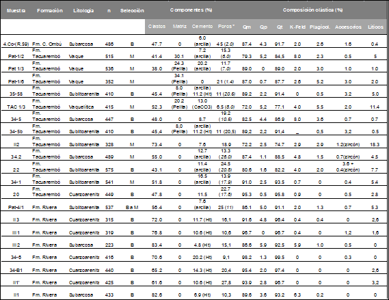
*The porosity (%), corresponds to secondary porosity. **If not indicated otherwise, they are mainly zircon and rutile. Ht = hematite; Qm = Monocrystalline Quartz, Qp = Polycrystalline Quartz, Qt = Total Quartz
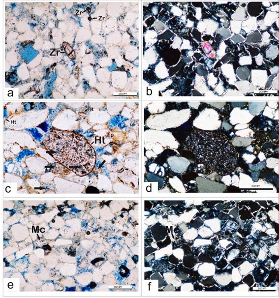
Figure 8: Photomicrographs taken with a petrographic microscope. Observed under a. natural light and b. polarized light, the presence of zircon as an accessory mineral in the Fm. Tacuarembó and also c. natural light and d. polarized light, the presence of microcline clasts for this unit; identified under e. natural light and f. polarized light, secondary porosity product of the dissolution of intraclasts and hematite-type cement in the Fm. Rivera
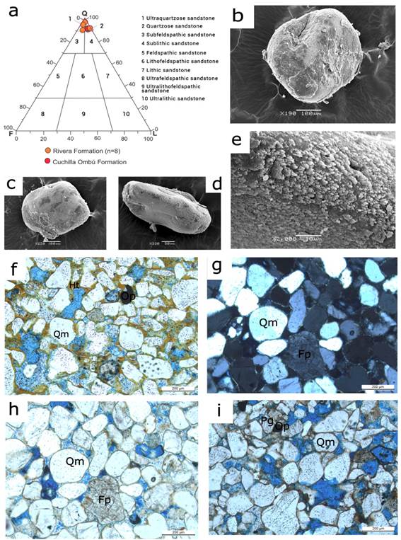
Figure 9: a. Classification of the sandstones of the Rivera and Cuchilla Ombú Formations. b-e. Microphotographs taken with a scanning electron microscope (b-c of the Rivera Formation and d-e of the Cuchilla Ombú Formation), rounded and of good sphericity clasts, with polished surface, typical of clasts of aeolian origin. e. Detail of (d) showing clays as a grain coating. f. Clast-supported quartz arenite, with very good granulometric selection, where the hematite cement is observed coating the clasts. g-h. Well selected subarkose, with tangential and concave-convex contacts, where microcline and orthoose clasts are observed; the cement corresponds to hematite and calcite. (g with crossed nicols). i. Quartz sublithic arenite, with good to moderate selection, contacts between clasts predominantly concave-convex, observing clay cement. Qm: Monocrystalline quartz, Op: opaque, Pg: Plagioclase, Fp: Feldspar
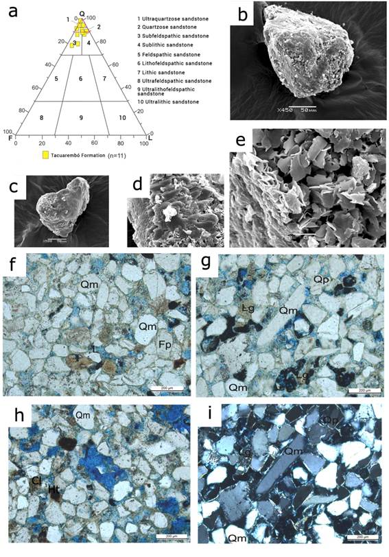
Figure 10: a. Classification of the sandstones of the Tacuarembó Formation. Microphotographs taken with a scanning electron microscope for the Tacuarembó Formation: b-c. subangular quartz clasts, d-e. Clays of the group of smectites. f. Well selected sublithic arenite, with subangular to subrounded clasts, predominantly straight clast contacts, clay and cement matrix. Note the primary and secondary porosity. g. i. Subarkose with moderate selection. It presents clay cement with low primary porosity and high secondary porosity, acicular clasts are observed. In natural light (g) and with crossed nicols (i). h. Well selected sublithic arenite, with hematite and clay cement. It is noted that in some sectors there is greater interstitial (primary) porosity and in other sectors greater cementation is observed and therefore, less porosity. Qm: Monocrystalline quartz, Lg: Granitic lithics. Fp: Feldspars
According to the total and effective porosity values obtained by petrographic analysis, it can be observed how the Rivera Formation and the Cuchilla Ombú Formation, both of aeolian origin, present higher values not only of total porosity, but also of effective porosity than the Tacuarembó Formation, becoming excellent aquifer units. The total porosity values determined for the Tacuarembo Formation are similar to other mean values reported in the literature for this formation, with total porosity values ranging from 20 to 24% and effective porosity from 15.2 to 19.2%29.
4. Conclusions
Sedimentary petrography is of great importance for the analysis of porosity in sedimentary formations, a fundamental parameter to determine the ability to transmit, drain and store water in a given formation. In turn, the mineralogy of clastic components influences the quality of groundwater and, therefore, its aptitude for different uses.
The porosity study shows average values of total porosity of 17% and effective porosity of 14% for the Rivera and Cuchilla Ombú aquifer units. For the Tacuarembó unit, the average total porosity is 15% and 9% for the effective porosity. These values demonstrate the greater capacity that the sandstones corresponding to the Rivera and Cuchilla Ombú formations have to store, drain and transmit over those of the Tacuarembó Formation.
Regarding the petrographic studies, compositional differences can be identified between the Rivera and the Tacuarembó Formations, the former being essentially quartz-arenites and the latter predominantly subarkose and sublithic arenite sandstones. This composition is reflected in clear differences in primary porosity. These conclusions agree with other published research, where the same methodology is applied in the GAS sandstones30.

